So we have been very sick after a pretty cool vacation through rural America around and through the Smoky Mountains. Needless to say, we couldn’t end the year on a recap post nor start right on the mark of the new year. But being sick gave us time to think a bit about a new project that will be an ongoing series of posts relating to the Central Business District or CBD in Tampa. While we couldn’t readily find out what Tampa’s actual CBD’s boundaries are, this is the closest one.
Out of our own spite we are not including Harbor Island, that is largely private and has limited access. We also are not including Channelside either as the existing tracks or at least the footprint of them is our boundary. Geographically, Davis Island has a clean break from the Tampa’s downtown core because of the Garrison Channel, so we are dropping that too. We still consider Central Ave or what is left of it as part of the Downtown Core. Encore is debatable because we feel that is still east downtown, however for now, we will leave that one out (City of Tampa agrees as well). We also agree with the consensus that the Hillsborough River, the water channels and I-275 are all limits of the CBD.
Here is our own CBD map, note our purple boundary.
The purpose of our CBD map is to mark the good, bad and ugly of all things related to transportation, land-use and development. Think of this like a map where you report potholes BUT in this instance TSTB is reporting bad urbansim along with some good things to keep or duplicate. The icons in this map will relate to the general issues. For example, if you see a bike icon then is bicycle related and so on.
Here is what we noted so far. The cool thing is that these same pictures are in this map as a reference!
Below are photos around the AER, a newly built upscale residential tower in downtown. These are located with the walking icon near the river (west side) in our map.
These photos show poorly placed benches that somehow sailed through our zoning and building department reviews and hearings.
At the AER, along Cass St.
Along Tyler St. at the backside of the AER.
Here are some transportation issues we noted along the cycle track that terminates at E Kennedy Blvd and N Nebraska Ave.:

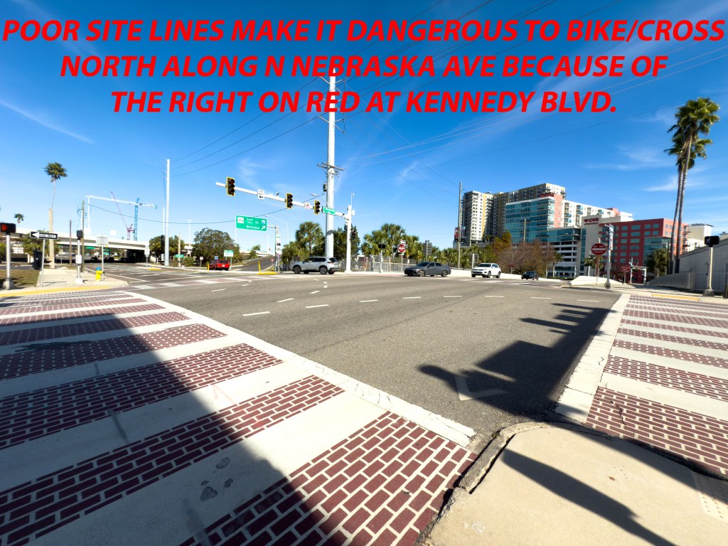
While it does not look bad, this intersection is actually raised a bit for Florida standards. This wonky elevation makes visibility difficult to gauge traffic ascending up along Nebraska and Kennedy (from Channelside).
Normally, this wouldn’t be a major issue but the cycle track end and begins here. To make matters more complicated, a Selmon Crosstown expressway ramp is less than 120 feet north from this intersection. Most true bicycle commutes (non-recreational) trips occur during peak hours and under the hot blazing sun. This intersection is significantly busier than what these photos portray. In the typical heat, it is not easy after biking a distance (in work clothes) to lug up-hill into this bike box to get into the north-flow bike lane (sorta) to then deal with right-turning cars appearing out of nowhere due to the raised elevation. After that drama, a cyclist would have to immediately deal with traffic trying to access the expressway ramp seconds later. Not fun.
This is one hell of a negotiation that no cyclists should deal with. Thank god for e-bikes which help to access this bike box easier (this track and intersection was built over five years ago)!
On our map, we noted that E Whiting St should have been a designated bikeway (for so many reasons- the trolley stop at Whiting being one). Funneling cyclists to Whiting and then eventually to the Nebraska intersection at E Jackson St would allow enough time to react to the elevation changes at Kennedy and observe traffic turning onto the expressway ramp. There is arguably no easy way to get to the southern end of downtown or Water Street through downtown. Unfortunately, this cycle track concretes this deficiency…as you are forced to use Jackson and then figure a way south. True, you can take Meridian Ave which has a trail but that trail is riddled with cars turning right through it. Unless you break traffic laws, one can’t simply and directly go further south down to the south side of Downtown. Lame.
Lastly, our progress is book-marked at this same cycle track but on the E Jackson Side.
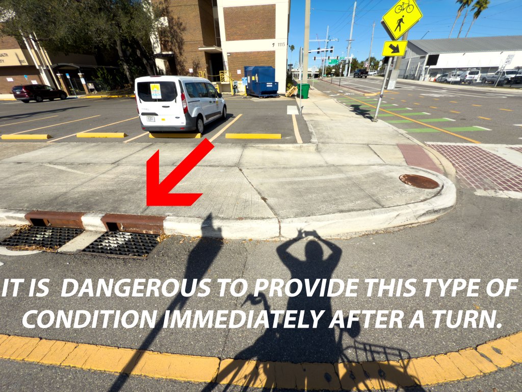
We don’t hate cycle tracks, we just hate bad design and negligence. We understand you need drainage in Tampa but we don’t understand why choose the worst drainage design and place that right after a turn.
Like our long term project Bicycle Boulevards Map (below), our Tampa CBD map will be similar where we will building upon mapping good and bad things. Yes, we will post significant updates on this blog about it…for both maps.
Please note that our CBD map isn’t a magic plan to fix downtown but rather for lessons learn. We know there were legitimate reasons why some development and infrastructure decisions were made. Sometimes it is zoning, state rules, old or grandfather-in legal issues, or specific owners and operators of roads. However, we wanted to make this map for the public and city leaders to make the right demands to improve their communities in downtown Tampa.
Happy New Year!

Leave a comment